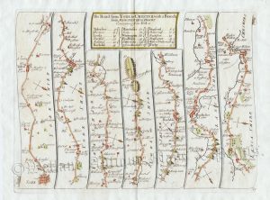
An interesting 18th Century road strip map — showiing the routes from Ferrybridge to Barnard Castle via Aberford, Wetherby, Boroughbridge, Ripon and Richmond; Ferrybridge to Wakefield via Pontefract; Stony Stratford to Derby via Northampton, Market Harborough, Leicester, Mountsorrel and Kegworth; Loughborough to Nottingham; and Nottingham to Grimsby via Newark, Lincoln and Market Raisen — which was engraved by Thomas Bowen and published in Sylvanus Urban’s The Gentleman’s Magazine (London: D. Henry, 1774).
‘The Gentleman’s Magazine’ was founded in London by Edward Cave (pen name: Sylvanus Urban) in 1731. It was the first ever periodical to use the term ‘magazine’; coming from the French / Arabic word for a ‘storehouse’. Focusing on an array of subjects including politics, the publication became very popular reaching sales of 10,000 in its first eight years and over 15,000 by the 1740s. Amongst its many contributors was Samuel Johnson who first found regular employment as a writer. ‘The Gentleman’s Magazine’ remained popular throughout the 18th and 19th centuries but by the early 20th century it sales had dropped to the extent that it was finally discontinued in 1922.
- This is an original copperplate engraving with later hand colour.
- Printed area is approximately 28.5cms by 17.8cms (including imprint).
- The map is in very good condition with decent margins; folds, as issued. There is some slight offset and age toning. Click on image for a better view.
- The item comes displayed in a ready to frame museum quality mount.
- Click on ‘Delivery Policy’ for postage costs.
- Guaranteed to be over 240 years old.