

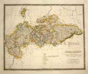
An interesting, detailed and finely engraved 19th century map of Western Germany which was published in Alexander Keith Johnston’s National Atlas of General Geography (Edinburgh: A. K. Johnston, 1855).
- This is an original steel engraving with original (outline) hand colour.
- Printed area is approximately 50cms by 61.3cms.
- The map is in very good condition with decent margins; centre fold, as issued. Click on image for a better view.
- Click on ‘Delivery Policy’ for postage costs.
- Guaranteed to be over 160 years old.
!['ALLEMAGNE [Germany] Par N. Sanson le Fils Geographe du Roy' c.1752](https://www.wellandantiquemaps.co.uk/wp-content/uploads/2023/01/Germany-Allemagne-du-Roy-001-copy-300x269.jpg)