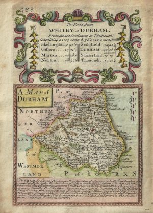
A finely engraved and accurate 18th century map of Durham, by the renowned John Cary, which appeared in his New & Correct English Atlas (London: 1787/1788). An original page of text relating to the county is included with this purchase.
First published in 1787/88, ‘Cary’s New & Correct English Atlas’ was the most revolutionary county atlas ever printed. The quaintness and charm of earlier mapmaking was replaced with a scientific rationality that emphasised detail, clarity and accuracy. Cary set a standard thereafter which other Cartographers were to follow, most notably, the Ordnance Survey.
- This is an original copperplate engraving with original hand colour.
- Printed area is approximately 26.5cms by 21.5cms.
- The map is in very good condition with decent margins. Click on image for a better view.
- Click on ‘Delivery Policy’ for postage costs.
- Guaranteed to be over 200 years old.