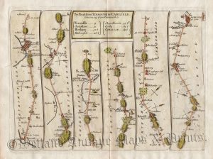
![Plate 73: The Road from HUNTINGDON to IPSWICH Com. Suffolk [via Ely & Bury St. Edmunds] by Thomas Gardner c.1719](https://www.wellandantiquemaps.co.uk/wp-content/uploads/2025/08/Huntingdon-to-Ipswich-Gardner-01-ed-scaled.jpg)
An interesting and rare early 18th century road strip map showing the route from Huntingdon to Ipswich — St. Ives, Erith, Sutton, Ely, Soham, Burt St. Edmunds, Woolpit, Stow Market and Needham — which was published in Thomas Gardner’s A Pocket-Guide To The English Traveller (London: J. Tonson & J. Watts, 1719).
Based on John Ogilby’s Britannia c.1675, Gardner’s road strip maps were of a reduced size making them more practical for the traveller. His atlas was, however, published only once making the maps rare to find.
- This is an original copperplate engraving with later hand colour.
- Printed area is approximately 27.2cms by 17.2cms.
- The map is in very good condition with decent margins. Click on image for better view.
- The item comes displayed in a ready to frame museum quality mount.
- Click on ‘Delivery Policy‘ for postage costs.
- Guaranteed to be over 300 years old.