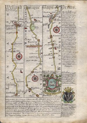
Actual Title: The Road from Tinmouth in Northumberld to ye City of CARLISLE in Cumbert.d By THO. GARDNER
An interesting and rare early 18th century road strip map showing the route from Tynemouth to Carlisle — via Newcastle-upon-Tyne, Hexham, Haltwhistle and Crosby-on-Eden — which was published in Thomas Gardner’s A Pocket-Guide To The English Traveller (London: J. Tonson & J. Watts, 1719).
Based on John Ogilby’s Britannia c.1675, Gardner’s road strip maps were of a reduced size making them more practical for the traveller. His atlas was, however, published only once making the maps rare to find.
- This is an original copperplate engraving with later hand colour.
- Printed area is approximately 27.2cms by 17cms.
- The map is in very good condition. The left margin (lowe scroll) is cropped, as issued. Click on image for better view.
- The item comes displayed in a ready to frame museum quality mount.
- Click on ‘Delivery Policy’ for Postage costs.
- Guaranteed to be over 300 years old.