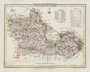
An interesting and attractive 17th century map of Berkshire which was produced by Robert Morden (engraver: Sutton Nicholls) for Camden’s Britannia (London: Swale, Awnshaw & Churchill, 1695 – 1772). Bishop Gibson described the maps from this series as “much the fairest and most correct of any that have yet appeared”. The maps are also notable for using up to three different mileage scales, none of which are based on the statute mile!
This particular map can be identified as a first edition as it includes the place name ‘Stedes’ in the Theale Hundred. This was erased for the next edition.
- This is an original copperplate engraving (good early impression) with later hand colour.
- Printed area is approximately 42cms by 35.7cms.
- The map is in very good condition, on strong paper and with decent margins. Click on image for a better view.
- Click on ‘Delivery Policy’ for postage costs.
- Guaranteed to be over 300 years old.