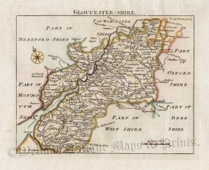
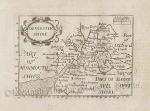
A very attractive and uncommon 18th century map of Gloucestershire which appeared in Thomas Kitchin and Thomas Jeffery’s The Small English Atlas (London: Robert Sayer, 1787-1796). An interesting feature is the topographical information at the foot of the map describing of the county’s towns and cities, parliamentary representation and market days.
- This is an original copperplate engraving with later hand colour.
- Printed area is approximately 13.5cms by 18cms.
- The map is in very good condition with decent margins; horizontal centrefold, as issued. Click on image for a better view.
- The item comes displayed in a ready to frame museum quality mount.
- Click on ‘Delivery Policy’ for postage costs.
- Guaranteed to be over 200 years old.