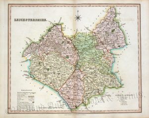
A detailed, skilfully engraved and finely hand coloured early 19th century map of Leicestershire which was published in [Charles] Smith’s New English Atlas (London: C. Smith, 1808 2nd ed.). This was one of the finest series of county maps ever produced and help establish Britain as the world leader in 19th century map making.
- This is an original copperplate engraving with original hand colour.
- Printed area is approximately 49.1cms by 43.8cms.
- The map is in very good condition with decent margins; centrefold, as issued. Click on image for a better view.
- Click on ‘Delivery Policy’ for postage costs.
- Guaranteed to be over 200 years old.