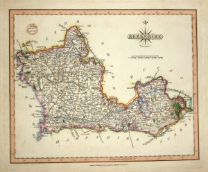
An attractive and extremely rare 17th century miniature map of Berkshire which was published in John Bill’s The Abridgement of Camden’s Britania…’ (London: J. Bill,1626).
John Bill fl. 1591-1630 was a publisher and bookseller who worked in London from around 1591 until his death in 1630. His most notable publication was a miniature county atlas, ‘The Abridgement of Camden’s Britania’, which he issued in 1626. Based on the surveys of Christopher Saxton and finely engraved (engraver unknown), these were the first county maps to show longitude and latitude — based on a prime meridian running through the Azores as devised by Mercator. Although similar in size and appearance to the Van Den Keere / Miniature Speed maps, the Bill maps are extremely rare to find and are much sought after by collectors as the atlas was published in only one relatively minor edition.
- This is an original copperplate engraving.
- Printed area is approximately 12.1cms by 8.8cms.
- The map is in very good condition with decent margins. There is printed text on the reverse. Click on image for better view.
- The item comes displayed in a ready to frame museum quality mount.
- Click on ‘Delivery Policy’ for Postage costs.
- Guaranteed to be over 390 years old.