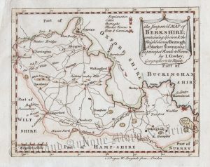
A finely engraved and accurate 19th century map of Berkshire which appeared in John Cary’s New & Correct English Atlas* (London: 1818); John Cary (c.1754-1835) is generally regarded as one of the greatest names in British cartography as his maps were unsurpassed for their quality, craftsmanship and detail. The original page of text relating to the county is included in the purchase.
*First published in 1787/88, Cary’s ‘New & Correct English Atlas’ was the most revolutionary county atlas ever printed. The quaintness and charm in earlier mapmaking was replaced with a scientific rationality that emphasised detail, clarity and accuracy. Cary set a standard thereafter which other cartographers were to follow, most notably, the Ordnance Survey. The atlas proved to be so popular that for the 1809 edition, an entirely new set of maps had to be engraved as the original plates had become so worn!
- This is an original copperplate engraving with original hand colour.
- Printed area is approximately 26.5cms by 21.8cms.
- The map is in very good condition with decent margins. Click on image for a better view.
- Click on ‘Delivery Policy’ for postage costs.
- Guaranteed to be over 190 years old.