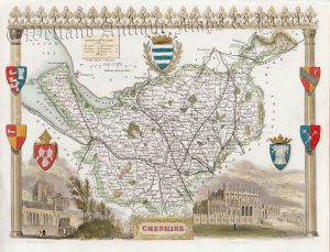
A neatly engraved and attractive 19th Century map of Cheshire which appeared in Samuel Lewis’s Topographical Dictionary of England (London: S. Lewis, 1831).
- This is an original steel engraving with later hand colour.
- Printed area is approximately 31.3cms by 24cms (including imprint).
- The map is in very good condition with decent margins; vertical folds, as issued. Click on image for a better view.
- Click on ‘Delivery Policy’ for postage costs.
- Guaranteed to be over 175 years old.