

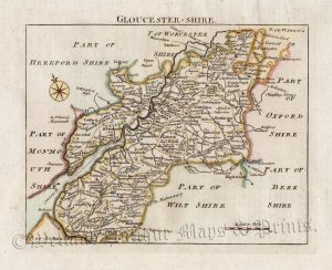
An interesting 19th Century map of Gloucestershire which was drawn and engraved by R. Creighton and J. & C. Walker, respectively, and published in Samuel Lewis’s English Topographical Dictionary (London: S. Lewis, 1840-1849).
- This is an original steel engraving with original hand colour.
- Printed area is approximately 25.2cms by 24cms.
- The map is in very good condition with decent margins. Click on image for a better view.
- Click on ‘Delivery Policy’ for postage costs.
- Guaranteed to be over 160 years old.
!['GLOCESTERSH.' [Gloucestershire] by 'Reuben Ramble' (Rev. Samuel Clark) c.[1844?] 1845](https://www.wellandantiquemaps.co.uk/wp-content/uploads/2023/01/Glouc-Ramble-001-copy_0-300x380.jpg)