!['LEICESTERSH.' by 'Reuben Ramble' (Rev. Samuel Clark) c.[1844?] 1845](https://www.wellandantiquemaps.co.uk/wp-content/uploads/2023/01/leic-Ramble-001-copy.jpg)
!['LEICESTERSH.' by 'Reuben Ramble' (Rev. Samuel Clark) c.[1844?] 1845 - Image 2](https://www.wellandantiquemaps.co.uk/wp-content/uploads/2023/01/Leic-Text-Ramble-001-copy.jpg)
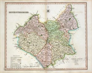
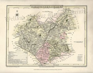
A rare, attractive and unusual 19th Century map of Leicestershire which appeared in Reuben Ramble’s Travels through the Counties of England (London: Darton & Clark, [1844?]1845-1850)**. The original page of text which accompanies the map is included with the purchase.
‘Reuben Ramble’ was the pseudonym of the Reverend Samuel Clark who produced this work to help educate children in national and local geography. Each county is represented by a small but detailed map* surrounded with various topographical images — in the case of Leicestershire, this includes views of fox hunting, cheese making, a stocking frame and an adyllic scene of cattle and sheep. As children have a tendency to maltreat their books, the maps from this series are comparatively rare to find in good condition.
*The map is a lithographic transfer of the one which appeared in “Miller’s new Miniature Atlas” in c.1821; Darton & Clark later acquiring the plates.
- This is an original lithograph with original hand colour.
- Printed area is approximately 14.8cms by 19.2cms.
- The map is in very good condition with decent margins. Click on image for a better view.
- The item comes displayed in a ready to frame museum quality mount.
- Click on ‘Delivery Policy’ for postage costs.
- Guaranteed to be over 165 years old.
**This map may have come from a hitherto unrecorded 1844 edition.