

An attractive and detailed mid 19th century map of Norfolk which was drawn and engraved by Joshua Archer and published in Tallis’s Topographical Dictionary of England and Wales (London: L. Tallis, 1855).
- This is an original steel engraving with original hand colour.
- Printed area is approximately 23.7cms by 18.8cms..
- The map is in very good condition with decent margins. Click on image for a better view.
- The item comes displayed in a ready to frame acid free mount.
- Click on ‘Delivery Policy’ for postage costs.
- Guaranteed to be over 160 years old.
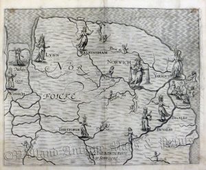
!['A MAPP OF THE COUNTY OF NORFOLCK WITH ITS HUNDREDS' [Norfolk] by Richard Blome c.1673](https://www.wellandantiquemaps.co.uk/wp-content/uploads/2023/01/Norfolk-Blome-copy-300x236.jpg)

