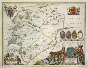
A detailed, attractive and rare early 19th century map of Rutland* which was finely engraved by Benjamin Baker and published in Laurie And Whittle’s New And Improved English Atlas (London: Laurie & Whittle, 1807). The original page of descriptive text which accompanies the map is included.
- This is an original copperplate engraving with fine original hand colour.
- Printed area is approximately 23.1cms by 18.6cms (including imprint).
- The map is in very good condition with decent margins. Click on image for a better view.
- The item comes displayed in a ready to frame acid free mount.
- Click on ‘Delivery Policy’ for postage costs.
- Guaranteed to be over 200 years old.
*The map was originally the property of Bradford Public Library and has a stamp on the reverse.