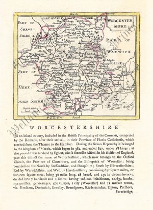
A detailed and attractive early 19th century county map of Worcestershire which was drawn and engraved by H. Cooper and published in Benjamin Capper’s A Topographical Dictionary of the United Kingdom (London: Richard Phillips*, 1808).
*The publisher, Richard Phillips (1767-1840), had a truly remarkable life. He first made a name for himself by founding the Leicester Herald in 1792. A year later, however, he was sentenced to 18 months in Leicester Gaol for selling Thomas Paine’s ‘Rights of Man’, a work considered seditious at the time. His problems were further compounded when his home and offices burnt to the ground in 1795. Aided by the insurance money, he moved to London and began publication of the Antiquarians’ Magazine. His reputation grew to the extent that he was made Sheriff of London and Middlesex in 1807 and knighted the following year. Despite bankruptcy in 1811, he continued in business until 1823.
- This is an original copperplate engraving with fine original hand colour.
- Printed area is approximately 17.6cms by 10.7cms (including imprint).
- The map is in very good condition with decent margins. Click on image for a better view.
- The item comes displayed in a ready to frame museum quality mount.
- Click on ‘Delivery Policy’ for postage costs.
- Guaranteed to be over 200 years old.