Skip to content
Register
Login
Home
About Us
Contact Us
Feedback
Recent Additions
Shop Online
Login
Register
£
0.00
Search for:
Search
Our Range
Antique Maps
County Maps
Foreign Maps
Great Britain & Ireland with Regional Maps
Renowned Map Makers
Road Maps
Title Pages / Frontispieces
Town Plans
Fairy Range
Other Prints
Topography
Home
/
Antique Maps
/ Page 4
Antique Maps
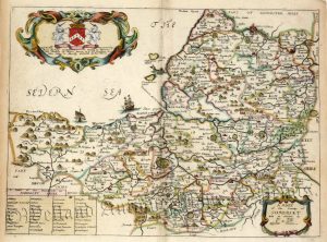
‘A MAPP OF THE COUNTY OF NORFOLCK WITH ITS HUNDREDS’ [Norfolk] by Richard Blome c.1673
£
275.00
Add to basket
Add to Wishlist
Add to Wishlist
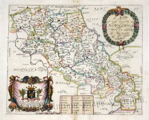
‘A MAPP OF THE COUNTY OF NORTHAMPTON WITH ITS HUNDREDS BY RIC: BLOME’ c.1673
£
195.00
Add to basket
Add to Wishlist
Add to Wishlist
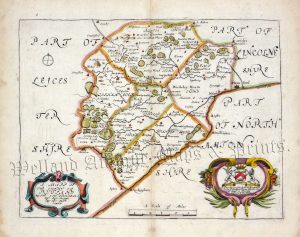
‘A MAPP OF THE COUNTY OF RUTLAND WITH ITS HUNDREDS BY RIC. BLOME’ c.1673
£
175.00
Add to basket
Add to Wishlist
Add to Wishlist
Out of stock
‘A MAPP of the County of SOMERSET, with its Hundreds’ by R. Blome c.1673
£
275.00
Read more
Add to Wishlist
Add to Wishlist
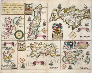
‘A MAPP OF THE ISLES OF WIGHT. JARSEY. GARNSEY, SARKE, MAN, ORCADES, AND SHETLAND, BY RIC: Blome by his Ma.ties Comand.’ c.1673
£
250.00
Add to basket
Add to Wishlist
Add to Wishlist
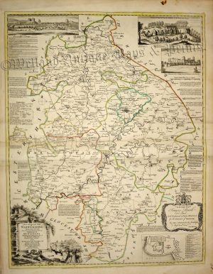
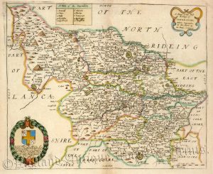
‘A Mapp of the West Ridings of YORKE=SHIRE: with its Wapontakes.’ by R. Blome c.1673
£
285.00
Add to basket
Add to Wishlist
Add to Wishlist
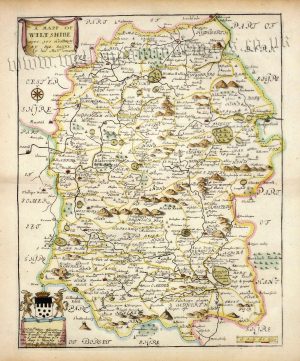
‘A MAPP OF WILTSHIRE’ by Richard Blome c.1673
£
250.00
Add to basket
Add to Wishlist
Add to Wishlist
‘A MAPP OF WORCESTER SHIRE WITH ITS HUNDREDS BY RIC BLOME’ c.1673
£
195.00
Add to basket
Add to Wishlist
Add to Wishlist
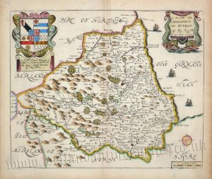
‘A MAPP OF YE BISHOPRICK OF DURHAM’ by Richard Blome c.1673
£
225.00
Add to basket
Add to Wishlist
Add to Wishlist
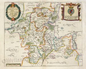
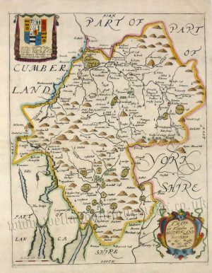
‘A MAPP OF YE COUNTIE OF WESTMORLAND’ by Richard Blome c.1673
£
195.00
Add to basket
Add to Wishlist
Add to Wishlist
‘A MAPP OF YE COUNTY OF ESSEX; WITH ITS HUNDREDS, BY RIC: BLOME’ c.1673
£
295.00
Add to basket
Add to Wishlist
Add to Wishlist
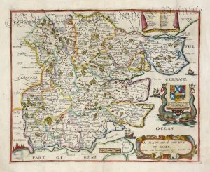
‘A MAPP of ye County of LINCOLNE’ (Lincolnshire) by Richard Blome c.1673
£
225.00
Add to basket
Add to Wishlist
Add to Wishlist
‘A MAPP of ye County of LINCOLNE’ [Lincolnshire] by Richard Blome c.1673 (with original colour)
£
250.00
Add to basket
Add to Wishlist
Add to Wishlist
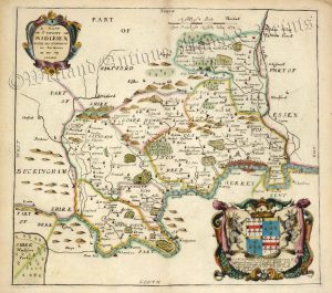
‘A MAPP of ye County of MIDLESEX WITH ITS HUNDREDS’ by Richard Blome c.1673
£
275.00
Add to basket
Add to Wishlist
Add to Wishlist
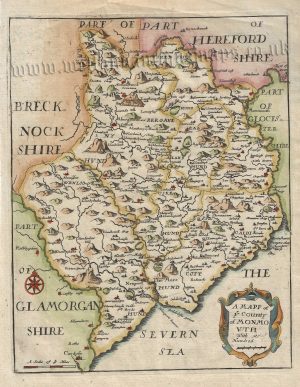
‘A MAPP of ye County of MONMOUTH with its Hundred’ by Richard Blome c.1693
£
95.00
Add to basket
Add to Wishlist
Add to Wishlist
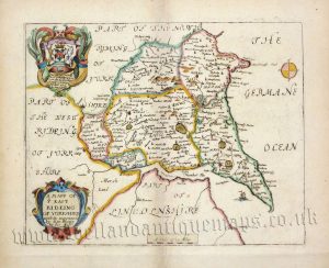
‘A MAPP OF YE EAST RIDEING OF YORKSHIRE with its wapontacks’ by Richard Blome c.1673
£
225.00
Add to basket
Add to Wishlist
Add to Wishlist
‘A Modern MAP of DORSET SHIRE, Drawn from the latest Surveys; Corrected and Improved by the best Authorities.’ by J. Ellis c.1765
£
95.00
Add to basket
Add to Wishlist
Add to Wishlist
‘A Modern Map of HAMPSHIRE’ by J. Ellis c.1796
£
95.00
Add to basket
Add to Wishlist
Add to Wishlist
‘A Modern MAP of HUNTINGDON SHIRE, Drawn from the latest Surveys’ by J. Ellis / W. Palmer c.1765-1790
£
75.00
Add to basket
Add to Wishlist
Add to Wishlist
‘A Modern MAP of NORTHUM-BERLAND Drawn from the latest Surveys’ by J. Ellis c.1765
£
75.00
Add to basket
Add to Wishlist
Add to Wishlist
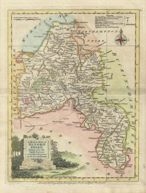
‘A Modern MAP of OXFORD-SHIRE’ by J. Ellis c.1765
£
75.00
Add to basket
Add to Wishlist
Add to Wishlist
‘A Modern MAP of STAFFORD-SHIRE’ by J. Ellis c.1765
£
75.00
Add to basket
Add to Wishlist
Add to Wishlist
‘A Modern MAP of STAFFORD-SHIRE, Drawn from the latest Surveys;’ by J. Ellis c.1796
£
85.00
Add to basket
Add to Wishlist
Add to Wishlist
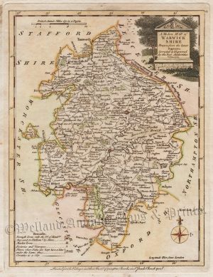
‘A Modern MAP of WARWICK SHIRE Drawn from the latest Surveys …’ by J. Ellis / W. Palmer c.1765
£
85.00
Add to basket
Add to Wishlist
Add to Wishlist
‘A Modern MAP of WILT SHIRE Drawn from the latest Surveys’ by J. Ellis / W. Fowler c.1765
£
95.00
Add to basket
Add to Wishlist
Add to Wishlist
‘A Modern MAP of WORCESTER SHIRE, Drawn from the latest Surveys …’ by J. Ellis / W. Fowler c.1765
£
80.00
Add to basket
Add to Wishlist
Add to Wishlist
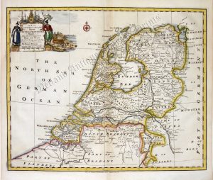
‘A New & Accurate MAP of the SEVEN UNITED PROVINCES.’ by Sieur Robert De Vaugondy / J. Gibson c.1760
£
75.00
Add to basket
Add to Wishlist
Add to Wishlist
‘A New & correct Map of the Counties of GLOCESTER & MONMOUTH Engraved from an actual Survey.’ by John Harrison c.1786-1791
£
110.00
Add to basket
Add to Wishlist
Add to Wishlist
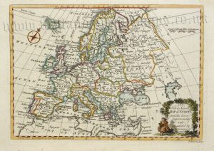
‘A New and Accurate MAP of EUROPE from the latest Improvements and Regulated by Astronomical Observations.’ by T. Bowen c.1768
£
85.00
Add to basket
Add to Wishlist
Add to Wishlist
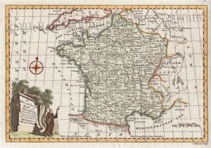
‘A New and Accurate MAP of FRANCE from the latest Improvements …’ by T. Bowen c.1773
£
65.00
Add to basket
Add to Wishlist
Add to Wishlist
‘A New and ACCURATE MAP of Island of JAMAICA…’ by Emanuel Bowen c.1747
£
250.00
Add to basket
Add to Wishlist
Add to Wishlist
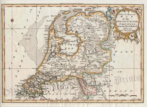
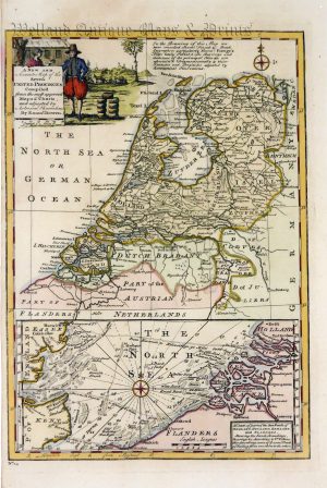
‘A NEW AND Accurate Map of the Seven UNITED PROVINCES Compiled from the most approv’d Maps & Charts’ by Emanuel Bowen c.1747
£
120.00
Add to basket
Add to Wishlist
Add to Wishlist
‘A New and Accurate MAP of WARWICKSHIRE Drawn from the best SURVEYS … ‘ by Thomas Kitchin c.1764
£
295.00
Add to basket
Add to Wishlist
Add to Wishlist
‘A NEW and CORRECT MAP of the Seven UNITED PROVINCES.’ (Netherlands) by Emanuel Bowen c.1751
£
145.00
Add to basket
Add to Wishlist
Add to Wishlist
‘A NEW Improved MAP of CORNWALL from the Best SURVEYS …’ by Thomas Kitchin (Ex ‘Large English Atlas’) c.1751
£
475.00
Add to basket
Add to Wishlist
Add to Wishlist
‘A New MAP 0f BEDFORD SHIRE Drawn from the best Authorities:’ by Thomas Kitchin c.1764
£
70.00
Add to basket
Add to Wishlist
Add to Wishlist
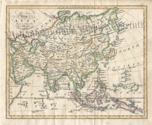
‘A New Map of ASIA drawn from the Best Authorities’ by Cadell & Smith c.1797
£
46.00
Add to basket
Add to Wishlist
Add to Wishlist
‘A New MAP of BEDFORD SHIRE Drawn from the best Authorities:’ by Thomas Kitchin c.1764
£
65.00
Add to basket
Add to Wishlist
Add to Wishlist
Out of stock
‘A New MAP of BERK SHIRE Drawn from the best Authorities:’ (original hand colour) by Thomas Kitchin c.1764
£
80.00
Read more
Add to Wishlist
Add to Wishlist
‘A New MAP of BRECKNOCK SHIRE Drawn from the best Authorities’ by Thomas Kitchin c.1765
£
55.00
Add to basket
Add to Wishlist
Add to Wishlist
←
1
2
3
4
5
6
7
…
64
65
66
→
Home
About Us
Contact Us
Feedback
Recent Additions
Shop Online
Login
Register
Shopping Basket
Scroll to Top


!['A MAPP OF THE COUNTY OF NORFOLCK WITH ITS HUNDREDS' [Norfolk] by Richard Blome c.1673](https://www.wellandantiquemaps.co.uk/wp-content/uploads/2023/01/Norfolk-Blome-copy-300x236.jpg)
!['A MAPP of ye County of LINCOLNE' [Lincolnshire] by Richard Blome c.1673 (with original colour)](https://www.wellandantiquemaps.co.uk/wp-content/uploads/2023/01/Blome-Lincolnshire-Orig-Colour-02-2-300x363.jpg)