Skip to content
Register
Login
Home
About Us
Contact Us
Feedback
Recent Additions
Shop Online
Login
Register
£
0.00
Search for:
Search
Our Range
Antique Maps
County Maps
Foreign Maps
Great Britain & Ireland with Regional Maps
Renowned Map Makers
Road Maps
Title Pages / Frontispieces
Town Plans
Fairy Range
Other Prints
Topography
Home
/
Antique Maps
/ Page 6
Antique Maps
‘A New MAP of NOTTINGHAM SHIRE Drawn from the best Authorities’ by Thomas Kitchin c.1764 (England Illustrated)
£
65.00
Add to basket
Add to Wishlist
Add to Wishlist
‘A New MAP of NOTTINGHAM SHIRE Drawn from the best Authorities’ by Thomas Kitchin c.1764 (England Illustrated)
£
65.00
Add to basket
Add to Wishlist
Add to Wishlist
‘A New MAP of NOTTINGHAM SHIRE Drawn from the latest Authorities.’ by T. Condor / A. Hogg c.1794
£
50.00
Add to basket
Add to Wishlist
Add to Wishlist
‘A New MAP of OXFORD SHIRE, Drawn from the best Authorities’ by Thomas Kitchin c.1764 (ex ‘England Illustrated’ with original hand colour)
£
85.00
Add to basket
Add to Wishlist
Add to Wishlist
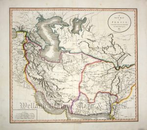
‘A NEW MAP OF PERSIA, FROM THE LATEST AUTHORITIES. By JOHN CARY. Engraver. 1821.’
£
195.00
Add to basket
Add to Wishlist
Add to Wishlist
‘A New MAP of RUTLAND SHIRE, Divided into the HUNDREDS: Drawn from the best Authorities’ by Thomas Kitchin c.1764 (ex ‘England Illustrated’ with original hand colour)
£
70.00
Add to basket
Add to Wishlist
Add to Wishlist
‘A New MAP of SHROPSHIRE, Drawn from the best Authorities’ by Thomas Kitchin c.1764 (ex ‘England Illustrated’ with original hand colour)
£
75.00
Add to basket
Add to Wishlist
Add to Wishlist
Out of stock
‘A New MAP of SOMERSET SHIRE Drawn from the best Authorities’ by Thomas Kitchin c.1764
£
90.00
Read more
Add to Wishlist
Add to Wishlist
‘A New MAP of STAFFORD SHIRE Drawn from the best Authorities’ by Thomas Kitchin c.1764
£
75.00
Add to basket
Add to Wishlist
Add to Wishlist
‘A New MAP of STAFFORD SHIRE, Drawn from the best Authorities’ by Thomas Kitchin c.1764
£
75.00
Add to basket
Add to Wishlist
Add to Wishlist
‘A NEW MAP OF SUFFOLK FROM THE LATEST AUTHORITIES’ by John Lodge c.1795
£
110.00
Add to basket
Add to Wishlist
Add to Wishlist
‘A New MAP of the COUNTY of Drawn from the best Authorities’ by Thomas Kitchin c.1765
£
125.00
Add to basket
Add to Wishlist
Add to Wishlist
‘A NEW MAP of the COUNTY of HUNTINGDON Divided into Hundreds’ by C. Smith c.1808
£
95.00
Add to basket
Add to Wishlist
Add to Wishlist
‘A NEW MAP of the COUNTY of LEICESTER Divided into Hundreds’ by Charles Smith c.1804
£
110.00
Add to basket
Add to Wishlist
Add to Wishlist
‘A New MAP of the COUNTY of SUFFOLK, Drawn from the best Authorities’ by Thomas Kitchin c.1764
£
85.00
Add to basket
Add to Wishlist
Add to Wishlist
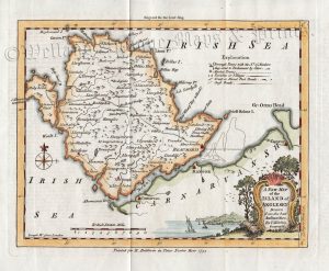
‘A NEW MAP of the ISLAND of ANGLESEY Drawn from the best Authorities. By T. Kitchin’ c.1755 /1756
£
65.00
Add to basket
Add to Wishlist
Add to Wishlist
‘A New MAP of the ISLE of WIGHT, Drawn from the best Authorities’ by Thomas Kitchin c.1764
£
85.00
Add to basket
Add to Wishlist
Add to Wishlist
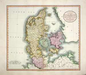
‘A NEW MAP OF THE KINGDOM OF DENMARK…’ By John Cary c.1801/1808
£
125.00
Add to basket
Add to Wishlist
Add to Wishlist
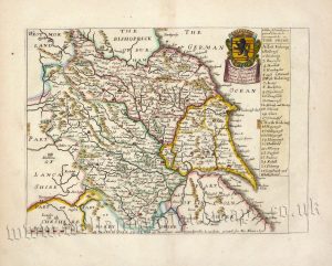
‘A New MAP of the NORTH RIDING of YORK SHIRE, Drawn from the best Authorities’ by Thomas Kitchin c.1764
£
95.00
Add to basket
Add to Wishlist
Add to Wishlist
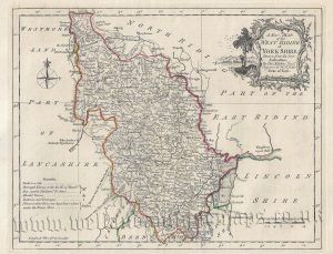
‘A New MAP of the WEST RIDING of YORK SHIRE, Drawn from the best Authorities’ by Thomas Kitchin c.1764
£
110.00
Add to basket
Add to Wishlist
Add to Wishlist
‘A New MAP of WESTMORE-LAND Drawn from the best Authorities’ by Thomas Kitchin c.1765 (ex ‘England Illustrated’)
£
70.00
Add to basket
Add to Wishlist
Add to Wishlist
Out of stock
‘A NEW MAP OF WESTMORELAND, DIVIDED INTO ITS WARDS … By JOHN CARY Engraver.’ c.1801 / 1809
£
75.00
Read more
Add to Wishlist
Add to Wishlist
‘A New MAP of YORK SHIRE Drawn from the best Authorities’ by Thomas Kitchin c.1764
£
110.00
Add to basket
Add to Wishlist
Add to Wishlist
‘A NEW MAP of YORKSHIRE Drawn from the latest & best AUTHORITIES’ by Condor / Hogg c.1786
£
120.00
Add to basket
Add to Wishlist
Add to Wishlist
‘A NEW MAPPE OF THE ROMANE EMPIRE newly described by John Speede ..’ c.1676
£
1,250.00
Add to basket
Add to Wishlist
Add to Wishlist
‘A PLAN of LONDON and its ENVIRONS.’ by R. Creighton / J. & C. Walker / S. Lewis c.1835
£
450.00
Add to basket
Add to Wishlist
Add to Wishlist
Out of stock
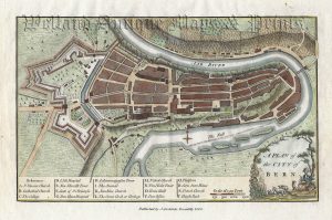
‘A PLAN of the CITY of BERN’ (Berne, Switzerland) by J. Stockdale c.1800
£
46.00
Read more
Add to Wishlist
Add to Wishlist
‘A Table of ye Divisions or parts wth ye Hundreds or wapontaks in YORK SHIRE’ by Richard Blome c.1673
£
275.00
Add to basket
Add to Wishlist
Add to Wishlist
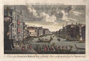
‘A View of an ITALIAN REGATTA or Gondola Race on the Grand Canal at VENICE & c.’ by T. Middleton c.1778
£
65.00
Add to basket
Add to Wishlist
Add to Wishlist
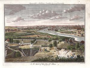
‘A View of the City of Paris’ by Prout / Middleton c.1778
£
60.00
Add to basket
Add to Wishlist
Add to Wishlist
‘ABERDEEN KINCARDINE’ by A. M. Perrot / A. Migneret c.1824-1835
£
40.00
Add to basket
Add to Wishlist
Add to Wishlist
‘AFRICA from the best Authorities By T. Kitchin Geog.r’ c.1759
£
65.00
Add to basket
Add to Wishlist
Add to Wishlist
‘AFRICA’ by ANON. c.1820
£
45.00
Add to basket
Add to Wishlist
Add to Wishlist
‘AFRICA’ by T. Starling c.1833
£
40.00
Add to basket
Add to Wishlist
Add to Wishlist
‘AFRICA.’ by John Dower c.1836
£
46.00
Add to basket
Add to Wishlist
Add to Wishlist
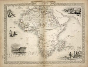
‘AFRICA.’ by John Tallis / J. Rapkin c.1851
£
185.00
Add to basket
Add to Wishlist
Add to Wishlist
‘AFRICA.’ by the Rev. Thomas Milner c.1897
£
25.00
Add to basket
Add to Wishlist
Add to Wishlist
Out of stock
‘AFRIIQUE’ (Africa) by J. Migeon c.1889
£
60.00
Read more
Add to Wishlist
Add to Wishlist
‘AFRIQUE’ (Africa) by Victor Levasseur c.1860s
£
95.00
Add to basket
Add to Wishlist
Add to Wishlist
‘ALLEMAGNE [Germany] Par N. Sanson le Fils Geographe du Roy’ c.1752
£
65.00
Add to basket
Add to Wishlist
Add to Wishlist
←
1
2
3
4
5
6
7
8
9
…
64
65
66
→
Home
About Us
Contact Us
Feedback
Recent Additions
Shop Online
Login
Register
Shopping Basket
Scroll to Top


!['ALLEMAGNE [Germany] Par N. Sanson le Fils Geographe du Roy' c.1752](https://www.wellandantiquemaps.co.uk/wp-content/uploads/2023/01/Germany-Allemagne-du-Roy-001-copy-300x269.jpg)