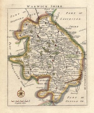
A decorative and highly detailed large folio map of Warwickshire which was engraved by Thomas Kitchin and published in The Large English Atlas (London: R. Sayer. T. Bowles, J. Bowles, 1764 ed.). The map is further embellished with prospect views of Tamworth, Guy’s Cliffe and Warwick Castle, and an overhead plan of Kenilworth Castle.
“The ‘Large English Atlas’ (1760), with maps by Emanuel Bowen and Thomas Kitchin, is justifiably regarded as one of the best county atlases published to that date. Combining cartographic detail with descriptive annotations, a vast amount of information was shown in these engravings. The large scale of these maps had not previously been attempted within an atlas although some of the counties were being mapped at larger scale.
Descriptive notes around the map area concerned the history, agriculture, economy, natural features, and people of note within that county and most of the maps included either plans, or panoramas, of the major towns within the county.” [Source: ‘Collecting Antique Maps’ by Jonathan Potter (1988) p,87).
- This is an original copperplate engraving with later hand colour.
- Printed area is approximately 52cms by 66.6cms.
- The map is in very good condition with decent margins; centrefold, as issued. There is a wax stain in the top border which is well away from the printed area. Click on image for a better view.
- Click on ‘Delivery Policy’ for postage costs.
- Guaranteed to be over 250 years old.