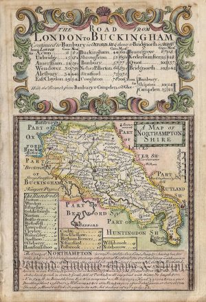
A curious and very rare 18th century ‘bird’s eye view’ map of Northanptonshire which appeared in George Bickham’s The British Monarchy or a Chorographical Description of all the Dominions Subject to the King of Great Britain (London: 1743-1754)
The British Monarchy’ is perhaps the most unusual county atlas ever printed. Unlike conventional maps, the observer is placed in a fictitious vantage point overlooking the county. In the case of Northamptonshire, the town of Northampton is seen closest to the foreground whilst other towns such as Wellingborough, Kettering and Oundle are further away. All the while one is presented with a quaint, 18th century image of rustic charm, beauty and tranquility.
Included with the map is two pages of text which demonstrate Bickham’s renowned skill as a calligrapher.
- This is an original copperplate engraving with later hand colour.
- Printed area is approximately 14.5cms by 25.5cms.
- The map is in very good condition with decent margins. Click on image for a better view.
- The item comes displayed in a ready to frame museum quality mount.
- Click on ‘Delivery Policy’ for postage costs.
- Guaranteed to be over 250 years old.