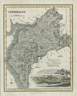
A finely engraved and detailed 19th century map of Cumberland which was published in Sidney Hall’s Travelling Atlas (London: Chapman & Hall, 1842). An interesting feature with maps of this period is the depiction of the then newly constructed (or proposed) railways.
- This is an original steel engraving with original hand colour.
- Printed area is approximately 18.5cms by 25cms.
- The map is in very good condition with decent mountable borders. There is a small, clean split to the left centrefold affecting the border but not the map itself. Click on image for a better view.
- The item comes displayed in a ready to frame acid free mount.
- Click on ‘Delivery Policy’ for postage costs.
- Guaranteed to be over 165 years old.