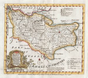
An attractive and detailed 19th century map of Kent, with a vignette view of Canterbury Cathedral & St. Augustine’s Gate, which was published by Archibald Fullarton & co. in The Parliamentary Gazetteer of England and Wales (London: Edinburgh & Glasgow: 1833-1843).
- This is an original steel engraving with later hand colour.
- Printed area is approximately 24cms by 19cms.
- The map is in very good condition with decent margins; vertical folds as issued. Click on image for a better view.
- The item comes displayed in a ready to frame museum quality mount.
- Click on ‘Delivery Policy’ for postage costs.
- Guaranteed to be over 160 years old.

!['KENT' by 'Reuben Ramble' (Rev. Samuel Clark) c.[1844?] 1845](https://www.wellandantiquemaps.co.uk/wp-content/uploads/2023/01/Kent-Ramble-001-copy-300x245.jpg)