

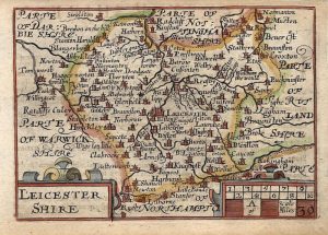
A finely engraved and accurate early 19th century map of Leicestershire which appeared in John Cary’s Traveller’s Companion* (London: J. Cary, 1810). John Cary (c.1754-1835) is arguably the best English map maker who ever lived as his maps are unsurpassed for their quality, accuracy and detail.
*The maps from the Traveller’s Companion, prepared at the request of the Postmaster General, were based on an entirely new survey of the Turnpike roads of England & Wales carried out by Cary from 1780 onwards. On publication, the maps proved to be immensely popular and had a considerable influence on the formative work of the Ordnance Survey Office which was established in 1791.
- This is an original copperplate engraving with original hand colour.
- Printed area is approximately 9.2cms by 14.6cms.
- The map is in very good condition with decent margins. Click on image for a better view.
- The item comes displayed in a ready to frame acid free mount.
- Click on ‘Delivery Policy’ for postage costs.
- Guaranteed to be over 200 years old.


!['LEICESTERSH.' by 'Reuben Ramble' (Rev. Samuel Clark) c.[1844?] 1845](https://www.wellandantiquemaps.co.uk/wp-content/uploads/2023/01/leic-Ramble-001-copy-300x382.jpg)