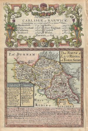
An interesting and detailed 19th century map of the North Riding of Yorkshire — with an attractive vignette of York Minster — which was drawn and engraved by G. Kemp and J. Neele & Co., respectively, and published in James Bell’s Comprehensive Gazeteer of England and Wales (Glasgow: Fullarton & co., 1836).
- This is an original steel engraving with later hand colour.
- Printed area is approximately 24cms by 18.9cms (including imprint).
- The map is in very good condition with decent margins; vertical folds, as issued. Click on image for a better view.
- The item comes displayed in a ready to frame museum quality mount.
- Click on ‘Delivery Policy’ for postage costs.
- Guaranteed to be over 180 years old.