
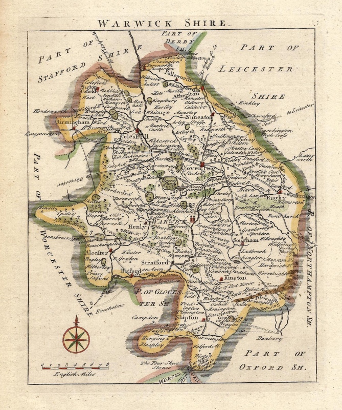
A charming and detailed mid 18th century map of Warwickshire which was published in Thomas Read’s* The English Traveller (London: 1746) and later, The Small British Atlas (London: 1753 – 1769)
- This is an original copperplate engraving with later hand colour.
- The approximate size of the printed area is 15.8cms by 19.8cms.
- The map is in very good condition with excellent margins. Click on image for a better view.
- The item comes displayed in a ready to frame museum quality mount.
- Click on ‘Delivery Policy’ for postage costs.
- Guaranteed to be over 240 years old.
*These maps are often attributed to John Rocque, an eminent Georgian cartographer of Huguenot descent; in reality, he was only a later publisher. Thomas Read, the original printer, was the main force in the production of the atlas. The maps themselves are based largely on those done by Herman Moll in 1708.
!['WIGORNIENSIS Comitatus et... WARWICENSIS' [Worcestershire & Warwickshire] by J. Blaeu c.1645](https://www.wellandantiquemaps.co.uk/wp-content/uploads/2023/01/Warks-Worc-Blaeu-copy-300x253.jpg)