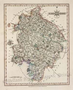
A detailed and attractive early 19th century map of Warwickshire which was engraved by Samuel Neele and published in Robin’s Atlas of England and Wales (London: J. Robins & Co.,1818).
- This is an original copperplate engraving with later hand colour.
- Printed area is approximately 19.7cms by 25.2cms (including imprint).
- The map is in very good condition with adequate margins. Click on image for a better view.
- The item comes displayed in a ready to frame museum quality mount.
- Click on ‘Delivery Policy’ for postage costs.
- Guaranteed to be over 190 years old.