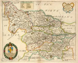
A detailed and attractive 19th century map of the West Riding of Yorkshire which was produced by William Nightingale Hughes (1817-1876) for The National Gazetteer of Great Britain and Ireland (London: Virtue & Co., 1868). An interesting feature is the depiction of the Victorian railway network running through the county.
- This is an original chromolithograph taken from a steel engraving.
- Printed area is approximately 30.4cms by 25.8cms (with imprint).
- The map is in very good condition with decent margins; centrefold, as issued. Click on image for a better view.
- Click on ‘Delivery Policy’ for postage costs.
- Guaranteed to be over 150 years old.

!['LEEDS.' by John Tallis / J. Rapkin / H. Winkles [Double Page] c.1855](https://www.wellandantiquemaps.co.uk/wp-content/uploads/2023/01/P1090007-copy-300x213.jpg)