Skip to content
Register
Login
Home
About Us
Contact Us
Feedback
Recent Additions
Shop Online
Login
Register
£
0.00
Search for:
Search
Our Range
Antique Maps
County Maps
Foreign Maps
Great Britain & Ireland with Regional Maps
Renowned Map Makers
Road Maps
Title Pages / Frontispieces
Town Plans
Fairy Range
Other Prints
Topography
Home
/
Antique Maps
/ Page 24
Antique Maps
‘GLAMORGAN SHYRE With the Sittuations of the cheife towne CARDYFF and sncient LANDAFFE described.’ by J. Speed c.1611 / 1612
£
725.00
Add to basket
Add to Wishlist
Add to Wishlist
Out of stock
‘GLAMORGAN-SHIRE’ by Robert Morden (‘Miniature Morden’) c.1701-1708
£
70.00
Read more
Add to Wishlist
Add to Wishlist
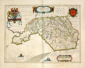
‘GLAMORGANENSIS COMITATUS; Vulgo GLAMORGAN SHIRE.’ by Joan Blaeu c.1645-1648 (French Text on reverse)
£
395.00
Add to basket
Add to Wishlist
Add to Wishlist
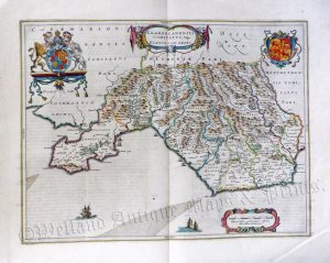
‘GLAMORGANENSIS COMITATUS; Vulgo GLAMORGAN SHIRE.’ by Joan Blaeu c.1645-1648 (Latin Text on reverse)
£
340.00
Add to basket
Add to Wishlist
Add to Wishlist
‘GLAMORGANSHIRE’ (with full wash colour) by G. Cole & J. Roper c.1809 / 1810
£
42.00
Add to basket
Add to Wishlist
Add to Wishlist
‘GLAMORGANSHIRE’ by G. Cole / J. Roper c.1809 / 1810
£
42.00
Add to basket
Add to Wishlist
Add to Wishlist
‘GLAMORGANSHIRE’ by Joshua Archer c.1860
£
30.00
Add to basket
Add to Wishlist
Add to Wishlist
‘GLAMORGANSHIRE’ by Leigh / Hall c.1835
£
25.00
Add to basket
Add to Wishlist
Add to Wishlist
‘GLAMORGANSHIRE’ by S. Lewis / R. Creighton / J. & C. Walker c.1844
£
36.00
Add to basket
Add to Wishlist
Add to Wishlist
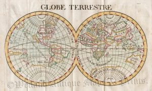
‘GLOBE TERRESTRE’ by Le Coq / P. Ganiere c.1723
£
195.00
Add to basket
Add to Wishlist
Add to Wishlist
‘GLOCESTER SHIRE’ (Gloucestershire) by J. Owen & E. Bowen c.1724
£
60.00
Add to basket
Add to Wishlist
Add to Wishlist
‘GLOCESTER SHIRE’ by John Bill c.1626
£
425.00
Add to basket
Add to Wishlist
Add to Wishlist
‘GLOCESTER SHIRE’ by R. Morden / T. Cox c.1717-1738 (‘Small Morden’)
£
95.00
Add to basket
Add to Wishlist
Add to Wishlist
‘GLOCESTER’ (Gloucester) by G. Cole & J. Roper c.1805 / 1810
£
105.00
Add to basket
Add to Wishlist
Add to Wishlist
‘GLOCESTERSH.’ (Gloucestershire) c.1821
£
36.00
Add to basket
Add to Wishlist
Add to Wishlist
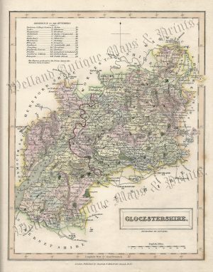
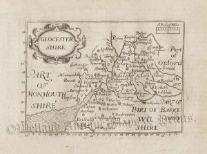
‘GLOCESTERSH.’ [Gloucestershire] by ‘Reuben Ramble’ (Rev. Samuel Clark) c.[1844?] 1845
£
95.00
Add to basket
Add to Wishlist
Add to Wishlist
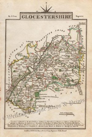
‘GLOCESTERSHIRE By JOHN CARY Engraver.’ c.1787 (New & Correct English Atlas)
£
65.00
Add to basket
Add to Wishlist
Add to Wishlist
‘GLOCESTERSHIRE By JOHN CARY Engraver.’ c.1818 (New & Correct English Atlas)
£
70.00
Add to basket
Add to Wishlist
Add to Wishlist
‘GLOCESTERSHIRE’ (Gloucestershire) by J. Archer / T. Johnson c.1863
£
40.00
Add to basket
Add to Wishlist
Add to Wishlist
‘GLOCESTERSHIRE’ (Gloucestershire) by J. Archer / W. Pinnock c.1837
£
25.00
Add to basket
Add to Wishlist
Add to Wishlist
Out of stock
‘GLOCESTERSHIRE’ (Gloucestershire) by J. Cary c.1810
£
32.00
Read more
Add to Wishlist
Add to Wishlist
‘GLOCESTERSHIRE’ (Gloucestershire) by James Wallis c.1816-1819
£
30.00
Add to basket
Add to Wishlist
Add to Wishlist
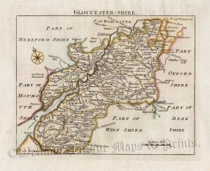
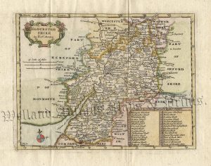
‘GLOCESTERSHIRE’ [Gloucestershire] (with full original wash colour) by G. Cole & J. Roper c.1805 / 1810
£
48.00
Add to basket
Add to Wishlist
Add to Wishlist
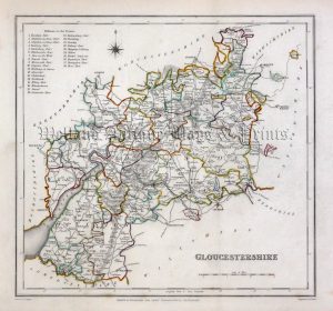
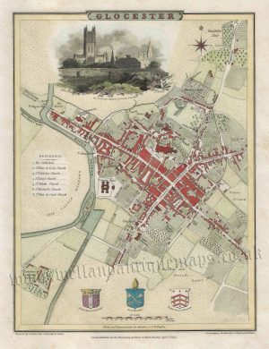
‘GLOCESTERSHIRE’ [Gloucestershire] by G. Cole & J. Roper c.1805 / 1810
£
48.00
Add to basket
Add to Wishlist
Add to Wishlist
‘GLOCESTERSHIRE.’ (Gloucestershire) by H. Teesdale (R. Rowe) c.1832
£
75.00
Add to basket
Add to Wishlist
Add to Wishlist
‘GLOCESTERSHIRE.’ (with text) by Sidney Hall c.1833
£
45.00
Add to basket
Add to Wishlist
Add to Wishlist
‘GLOCESTERSHIRE.’ by Fullarton & Co. / Gray & Son c.1843
£
48.00
Add to basket
Add to Wishlist
Add to Wishlist
‘GLOCESTRIA DUCATUS; GLOCESTER SHIRE.’ (Gloucestershire) by Joan Blaeu c.1645 (Latin Text Edition)
£
475.00
Add to basket
Add to Wishlist
Add to Wishlist
‘GLOCESTRIAE Comitatus olim sedes DOBUNORUM’ (Gloucestershire) by C. Saxton / W. Hole c.1637
£
325.00
Add to basket
Add to Wishlist
Add to Wishlist
‘GLOuCESTER SHIRE By Rob.t Morden’ c.1722
£
200.00
Add to basket
Add to Wishlist
Add to Wishlist
‘GLOUCESTER SHIRE Divided into its HUNDREDS’ by E. Bowen c.1758 / 1763
£
110.00
Add to basket
Add to Wishlist
Add to Wishlist
‘Gloucester Shire w.th some confining Towns’ by Jacob Van Langeren c.1643-1657
£
100.00
Add to basket
Add to Wishlist
Add to Wishlist
‘Gloucester Shire w.th some confining Towns’ by Jacob Van Langeren c.1643-1657
£
95.00
Add to basket
Add to Wishlist
Add to Wishlist
‘GLOUCESTER-SHIRE.’ by Thomas Read (John Rocque) c.1769
£
75.00
Add to basket
Add to Wishlist
Add to Wishlist
Out of stock
‘GLOUCESTERSHIRE’ (Hobson Fox Hunting Map) By J. & C. Walker c.1850
£
50.00
Read more
Add to Wishlist
Add to Wishlist
‘GLOUCESTERSHIRE’ (with Triangular Distance Table) by James Pigot (Pocket Topography) c.1841
£
55.00
Add to basket
Add to Wishlist
Add to Wishlist
‘GLOUCESTERSHIRE’ by Creighton / Walker /Lewis c.1840
£
40.00
Add to basket
Add to Wishlist
Add to Wishlist
‘GLOUCESTERSHIRE’ by Joshua Archer / Thomas Dugdale c.1842
£
35.00
Add to basket
Add to Wishlist
Add to Wishlist
‘GLOUCESTERSHIRE’ by Joshua Archer c.1860
£
35.00
Add to basket
Add to Wishlist
Add to Wishlist
‘GLOUCESTERSHIRE’ by Leigh / Hall c.1835
£
30.00
Add to basket
Add to Wishlist
Add to Wishlist
←
1
2
3
…
21
22
23
24
25
26
27
…
64
65
66
→
Home
About Us
Contact Us
Feedback
Recent Additions
Shop Online
Login
Register
Shopping Basket
Scroll to Top


!['GLOCESTERSH.' [Gloucestershire] by 'Reuben Ramble' (Rev. Samuel Clark) c.[1844?] 1845](https://www.wellandantiquemaps.co.uk/wp-content/uploads/2023/01/Glouc-Ramble-001-copy_0-300x380.jpg)


!['GLOCESTERSHIRE' [Gloucestershire] (with full original wash colour) by G. Cole & J. Roper c.1805 / 1810](https://www.wellandantiquemaps.co.uk/wp-content/uploads/2023/01/Gloucestersh-Cole-Roper-03-001-copy_0-300x381.jpg)
!['GLOCESTERSHIRE' [Gloucestershire] by G. Cole & J. Roper c.1805 / 1810](https://www.wellandantiquemaps.co.uk/wp-content/uploads/2023/01/Gloucestershire-Cole-Roper-004-001-copy-300x376.jpg)