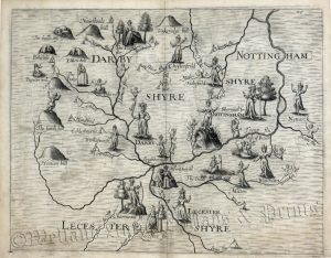
An attractive and finely engraved 18th century map of Derbyshire which appeared in Thomas Badeslade’s Chorographia Britanniae (London: W. H. Toms, 1741-1749).
Originally planned for an intended Royal tour of the country by George I, ‘Chorographia Britanniae’ was published later in the 1740s where it proved to be one of the most popular atlases of the 18th century. This was due, not least, to the engraver, William Henry Toms, whose work was of the highest standard. The maps were also popular for their inclusion of a panel of text describing the county’s towns and cities including the dates of markets and fairs and numbers of M.P.s
- This is an original copperplate engraving with later hand colour.
- Printed area is approximately 14.4cms by 15.4cms.
- The map is in very good condition.The top and bottom margin are close, as issued. Click on image for a better view.
- The item comes displayed in a ready to frame museum quality mount.
- Click on ‘Delivery Policy’ for postage costs.
- Guaranteed to be over 265 years old.