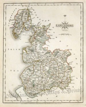
An attractive and detailed 19th century map of Lancashire which was originally drawn and engraved by G. Cole and J. Roper, respectively, and published in Thomas Dugdale’s Curiosities of Great Britain (London: Tallis & co, 1835-1843).The original accompanying pages of text are included. An interesting feature of the map is the depiction of the then newly constructed railways including the famous Liverpool to Manchester line.
- This is an original steel engraving with original hand colour.
- Printed area is approximately 18.8cms by 24.1cms (including plate number).
- The engraving is in very good condition with decent margins. Click on image for a better view.
- The item comes displayed in a ready to frame museum quality mount.
- Click on ‘Delivery Policy’ for postage costs.
- Guaranteed to be over 170 years old.