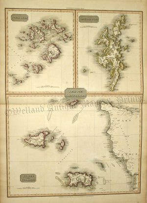
An interesting and detailed late 19th century map of the Channel Islands and published in George W. Bacon’s New Large Scale Ordnance Atlas of the British Isles (London: G. W. Bacon & Co., 1884).
- This is an original late 19th century chromolithograph.
- Printed area is approximately 30.4cms by 48.2cms.
- The map is in very good condition with adequate margins; centrefold, as issued. There is some minor staining. Click on image for a better view.
- Click on ‘Delivery Policy’ for postage costs.
- Guaranteed to be over 140 years old.