Skip to content
Register
Login
Home
About Us
Contact Us
Feedback
Recent Additions
Shop Online
Login
Register
£
0.00
Search for:
Search
Our Range
Antique Maps
County Maps
Bedfordshire Maps
Berkshire Maps
British Islands
Anglesey Maps
Channel Islands
General Maps of the Islands
Isle of Man
Isle of Wight
Scilly Isles
Buckinghamshire Maps
Cambridgeshire Maps
Cheshire Maps
Cornwall Maps
Cumberland Maps
Derbyshire Maps
Devon Maps
Dorset Maps
Durham Maps
Essex Maps
Gloucestershire Maps
Hampshire Maps
Herefordshire Maps
Hertfordshire Maps
Huntingdonshire Maps
Kent Maps
Lancashire Maps
Leicestershire Maps
Lincolnshire Maps
Middlesex Maps
Norfolk Maps
Northamptonshire Maps
Northumberland Maps
Nottinghamshire Maps
Oxfordshire Maps
Rutland Maps
Scottish Counties & Regions
Shropshire Maps
Somerset Maps
Staffordshire Maps
Suffolk Maps
Surrey Maps
Sussex Maps
Warwickshire Maps
Welsh Maps
Westmorland Maps
Wiltshire Maps
Worcestershire Maps
Yorkshire Maps
Foreign Maps
Great Britain & Ireland with Regional Maps
Renowned Map Makers
Road Maps
Title Pages / Frontispieces
Town Plans
Fairy Range
Other Prints
Topography
Home
/
Antique Maps
/
County Maps
/
British Islands
/ Channel Islands
Channel Islands
Original Antique Maps of the Channel Islands.
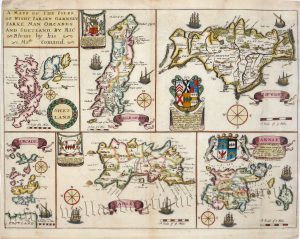
‘A MAPP OF THE ISLES OF WIGHT. JARSEY. GARNSEY, SARKE, MAN, ORCADES, AND SHETLAND, BY RIC: Blome by his Ma.ties Comand.’ c.1673
£
250.00
Add to basket
Add to Wishlist
Add to Wishlist
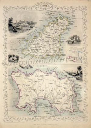
‘CHANNEL ISLANDS’ (with text) by J. Tallis / H. Winkles / E. Radclyffe / J. Rapkin c.1851
£
95.00
Add to basket
Add to Wishlist
Add to Wishlist
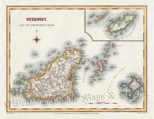
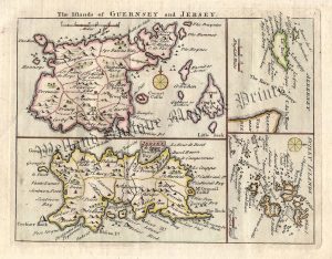
‘GUERNSEY. AND ITS INDEPENDENT ISLES.’ by Creighton / Walker / Lewis c.1840
£
40.00
Add to basket
Add to Wishlist
Add to Wishlist
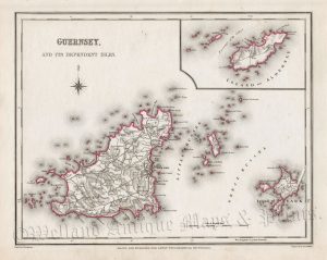
‘GUERNSEY. AND ITS INDEPENDENT ISLES.’ by Creighton / Walker / Lewis c.1846
£
40.00
Add to basket
Add to Wishlist
Add to Wishlist
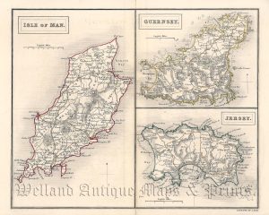
‘ISLE OF MAN.’ ‘GUERNSEY.’ ‘JERSEY.’ by Sidney Hall (4to) c.1842
£
30.00
Add to basket
Add to Wishlist
Add to Wishlist
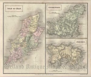
‘ISLE OF MAN.’ / ‘GUERNSEY.’ / ‘JERSEY.’ (with text) by Sidney Hall c.1833
£
36.00
Add to basket
Add to Wishlist
Add to Wishlist
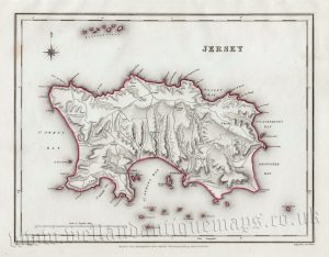
‘JERSEY’ by R. Creighton / J. & C. Walker / S. Lewis c.1844
£
36.00
Add to basket
Add to Wishlist
Add to Wishlist
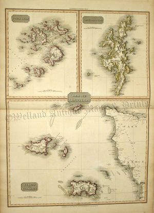
‘REMOTE BRITISH ISLES’ / SCILLY ISLES / SHETLAND ISLES / JERSEY AND GUERNSEY by John Pinkerton c.1812 / 1815
£
125.00
Add to basket
Add to Wishlist
Add to Wishlist
‘SARNIA INSULA, Vulgo GARNSEY: INSULA CAESAREA, Vernacule JARSEY.’ (Channel Islands: Jersey,Guernsey, Sark, Herme etc.) by Joan Blaeu c.1645
£
395.00
Add to basket
Add to Wishlist
Add to Wishlist
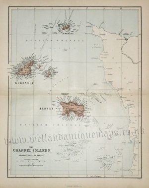
‘THE CHANNEL ISLANDS WITH THE ADJACENT COAST OF FRANCE’ by W. Hughes c.1868
£
20.00
Add to basket
Add to Wishlist
Add to Wishlist
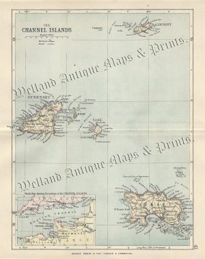
‘THE CHANNEL ISLANDS’ by G. W. Bacon c.1884
£
36.00
Add to basket
Add to Wishlist
Add to Wishlist
‘THE CHANNEL ISLANDS’ by John Bartholomew F.R.G.S. / Philip & Son c.1882
£
18.50
Add to basket
Add to Wishlist
Add to Wishlist
Out of stock
‘The Islands of GUERNSEY and JERSEY.’ / ‘ALDERNEY’ / ‘SCILLY ISLANDS’ by T. Read (J. Rocque) c.1769
£
70.00
Read more
Add to Wishlist
Add to Wishlist
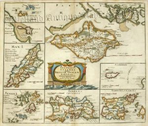
‘The Smaller ISLANDS – in the BRITISH OCEAN’ by J. Owen & E. Bowen c.1736
£
60.00
Add to basket
Add to Wishlist
Add to Wishlist
‘THE SMALLER ISLANDS in the BRITISH OCEAN’ by Robert Morden c.1722
£
185.00
Add to basket
Add to Wishlist
Add to Wishlist
Home
About Us
Contact Us
Feedback
Recent Additions
Shop Online
Login
Register
Shopping Basket
Scroll to Top