Skip to content
Register
Login
Home
About Us
Contact Us
Feedback
Recent Additions
Shop Online
Login
Register
£
60.00
Search for:
Search
Main Menu
Our Range
Antique Maps
County Maps
Bedfordshire Maps
Berkshire Maps
British Islands
Buckinghamshire Maps
Cambridgeshire Maps
Cheshire Maps
Cornwall Maps
Cumberland Maps
Derbyshire Maps
Devon Maps
Dorset Maps
Durham Maps
Essex Maps
Gloucestershire Maps
Hampshire Maps
Herefordshire Maps
Hertfordshire Maps
Huntingdonshire Maps
Kent Maps
Lancashire Maps
Leicestershire Maps
Lincolnshire Maps
Middlesex Maps
Norfolk Maps
Northamptonshire Maps
Northumberland Maps
Nottinghamshire Maps
Oxfordshire Maps
Rutland Maps
Scottish Counties & Regions
Shropshire Maps
Somerset Maps
Staffordshire Maps
Suffolk Maps
Surrey Maps
Sussex Maps
Warwickshire Maps
Welsh Maps
Westmorland Maps
Wiltshire Maps
Worcestershire Maps
Yorkshire Maps
East Riding Maps
General Maps of Yorkshire
North Riding Maps
West Riding Maps
Foreign Maps
Great Britain & Ireland with Regional Maps
Renowned Map Makers
Road Maps
Title Pages / Frontispieces
Town Plans
Fairy Range
Other Prints
Topography
Home
/
Antique Maps
/
County Maps
/
Yorkshire Maps
/ East Riding Maps
East Riding Maps
Original Antique Maps of the East Riding from the 17th to 19th Century.
“‘The East Riding of YORKSHIRE with Ainsty Liberty By JOHN CARY Engraver.’ c.1818” has been added to your basket.
View basket
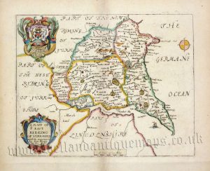
‘A MAPP OF YE EAST RIDEING OF YORKSHIRE with its wapontacks’ by Richard Blome c.1673
£
225.00
Add to basket
Add to Wishlist
Add to Wishlist
‘An ACCURATE MAP of the EAST RIDING of YORK SHIRE, Divided into its WAPONTAKES &c. Drawn from Surveys, with various additional Improvements … by Eman: Bowen Geog:r to HIS MAJESTY’ c.1762-1781
£
295.00
Add to basket
Add to Wishlist
Add to Wishlist
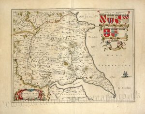
‘DUCATUS EBORACENSIS PARS ORIENTALIS; The East riding of Yorkshire’ by Joan Blaeu c.1645 (Latin Text Edition)
£
425.00
Add to basket
Add to Wishlist
Add to Wishlist
‘DUCATUS EBORACENSIS PARS ORIENTALIS; The East riding of Yorkshire’ by Joan Blaeu c.1645-1648 (Latin Text Edition)
£
325.00
Add to basket
Add to Wishlist
Add to Wishlist
‘EAST RIDING and AINSTY of YORKSHIRE by Fullarton & co. c.1834
£
40.00
Add to basket
Add to Wishlist
Add to Wishlist
‘EAST RIDING OF YORKSHIRE’ (Hobson Fox Hunting Map) By J. & C. Walker c.1850
£
45.00
Add to basket
Add to Wishlist
Add to Wishlist
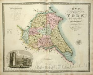
‘MAP OF THE EAST RIDING OF The County of YORK, FROM AN ACTUAL SURVEY’ by C. & J. Greenwood c.1834
£
200.00
Add to basket
Add to Wishlist
Add to Wishlist
‘PLAN OF HULL’ by G. W. Bacon c.1895
£
32.00
Add to basket
Add to Wishlist
Add to Wishlist
Out of stock
‘THE EAST RIDING of YORKSHIRE by Robert Morden’ c.1695
£
185.00
Read more
Add to Wishlist
Add to Wishlist
‘The East Riding of YORKSHIRE with Ainsty Liberty By JOHN CARY Engraver.’ c.1787
£
60.00
Add to basket
Add to Wishlist
Add to Wishlist
‘The East Riding of YORKSHIRE with Ainsty Liberty By JOHN CARY Engraver.’ c.1818
£
60.00
Add to basket
Add to Wishlist
Add to Wishlist
‘The EAST RIDING of YORKSHIRE, Drawn from the best Authorities’ by Thomas Kitchin c.1764
£
65.00
Add to basket
Add to Wishlist
Add to Wishlist
‘The EAST RIDING of YORKSHIRE, Drawn from the best Authorities’ by Thomas Kitchin c.1764
£
75.00
Add to basket
Add to Wishlist
Add to Wishlist
Out of stock
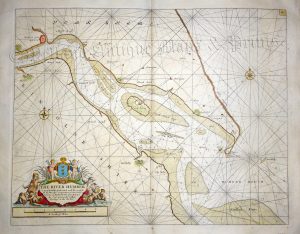
‘THE RIVER HUMBER’ by Capt. Greenville Collins c.1764
£
325.00
Read more
Add to Wishlist
Add to Wishlist
‘YORKSHIRE (THE EAST RIDING)’ by W. Hughes c.1868
£
20.00
Add to basket
Add to Wishlist
Add to Wishlist
‘YORKSHIRE EAST RIDING’ by Thomas Moule c.1840s
£
65.00
Add to basket
Add to Wishlist
Add to Wishlist
‘YORKSHIRE. E. RIDING’ by Leigh / Hall c.1835
£
25.00
Add to basket
Add to Wishlist
Add to Wishlist
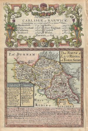
‘The NORTH & EAST RIDING of YORKSHIRE’ by J. Owen & E. Bowen c.1720-1764
£
60.00
Add to basket
Add to Wishlist
Add to Wishlist
Home
About Us
Contact Us
Feedback
Recent Additions
Shop Online
Login
Register
Shopping Basket
Scroll to Top