Skip to content
Register
Login
Home
About Us
Contact Us
Feedback
Recent Additions
Shop Online
Login
Register
£
0.00
Search for:
Search
Our Range
Antique Maps
County Maps
Bedfordshire Maps
Berkshire Maps
British Islands
Buckinghamshire Maps
Cambridgeshire Maps
Cheshire Maps
Cornwall Maps
Cumberland Maps
Derbyshire Maps
Devon Maps
Dorset Maps
Durham Maps
Essex Maps
Gloucestershire Maps
Hampshire Maps
Herefordshire Maps
Hertfordshire Maps
Huntingdonshire Maps
Kent Maps
Lancashire Maps
Leicestershire Maps
Lincolnshire Maps
Middlesex Maps
Norfolk Maps
Northamptonshire Maps
Northumberland Maps
Nottinghamshire Maps
Oxfordshire Maps
Rutland Maps
Scottish Counties & Regions
Shropshire Maps
Somerset Maps
Staffordshire Maps
Suffolk Maps
Surrey Maps
Sussex Maps
Warwickshire Maps
Welsh Maps
Anglesey Maps / Ynys Mon
Brecknockshire Maps
Caernarfonshire Maps
Cardigan / Ceredigion Maps
Carmarthenshire Maps
Denbighshire Maps
Flintshire Maps
General & Regional Maps of Wales
Glamorgan Maps
Merionethshire Maps
Monmouthshire Maps
Montgomery Maps
Pembrokeshire Maps
Radnorshire Maps
Westmorland Maps
Wiltshire Maps
Worcestershire Maps
Yorkshire Maps
Foreign Maps
Great Britain & Ireland with Regional Maps
Renowned Map Makers
Road Maps
Title Pages / Frontispieces
Town Plans
Fairy Range
Other Prints
Topography
Home
/
Antique Maps
/
County Maps
/
Welsh Maps
/ Glamorgan Maps
Glamorgan Maps
Original Antique Maps of the County of Glamorgan (
Morgannwg
).
‘A MAP OF GLAMORGAN SHIRE’ by J. Owen & E. Bowen c.1736
£
55.00
Add to basket
Add to Wishlist
Add to Wishlist
‘A New MAP of GLAMORGAN SHIRE, Drawn from the best Authorities’ by Thomas Kitchin c.1764
£
70.00
Add to basket
Add to Wishlist
Add to Wishlist
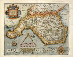
‘GLAMORGAN Comitatus qui olim pars Silurum’ by C. Saxton / W. Hole c.1607 (First Edition)
£
325.00
Add to basket
Add to Wishlist
Add to Wishlist
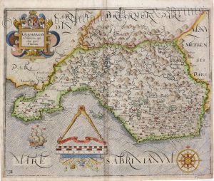
‘GLAMORGAN Comitatus, qui olim pars Silurum’ by Saxton / Kip c.1637
£
295.00
Add to basket
Add to Wishlist
Add to Wishlist
Out of stock
‘GLAMORGAN Shire.’ by Pieter Van Den Keere (‘Miniature Speed’) c.1646
£
65.00
Read more
Add to Wishlist
Add to Wishlist
‘GLAMORGAN SHYRE With the Sittuations of the cheife towne CARDYFF and sncient LANDAFFE described.’ by J. Speed c.1611 / 1612
£
725.00
Add to basket
Add to Wishlist
Add to Wishlist
Out of stock
‘GLAMORGAN-SHIRE’ by Robert Morden (‘Miniature Morden’) c.1701-1708
£
70.00
Read more
Add to Wishlist
Add to Wishlist
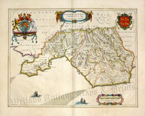
‘GLAMORGANENSIS COMITATUS; Vulgo GLAMORGAN SHIRE.’ by Joan Blaeu c.1645-1648 (French Text on reverse)
£
395.00
Add to basket
Add to Wishlist
Add to Wishlist
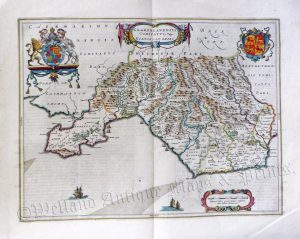
‘GLAMORGANENSIS COMITATUS; Vulgo GLAMORGAN SHIRE.’ by Joan Blaeu c.1645-1648 (Latin Text on reverse)
£
340.00
Add to basket
Add to Wishlist
Add to Wishlist
‘GLAMORGANSHIRE’ (with full wash colour) by G. Cole & J. Roper c.1809 / 1810
£
42.00
Add to basket
Add to Wishlist
Add to Wishlist
‘GLAMORGANSHIRE’ by G. Cole / J. Roper c.1809 / 1810
£
42.00
Add to basket
Add to Wishlist
Add to Wishlist
‘GLAMORGANSHIRE’ by Joshua Archer c.1860
£
30.00
Add to basket
Add to Wishlist
Add to Wishlist
‘GLAMORGANSHIRE’ by Leigh / Hall c.1835
£
25.00
Add to basket
Add to Wishlist
Add to Wishlist
‘GLAMORGANSHIRE’ by S. Lewis / R. Creighton / J. & C. Walker c.1844
£
36.00
Add to basket
Add to Wishlist
Add to Wishlist
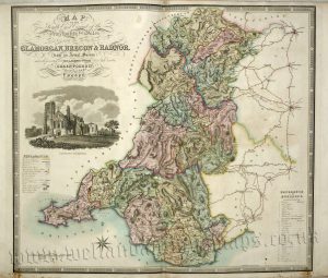
‘MAP OF THE South East Circuit of The Principality of Wales, Comprising the Counties of GLAMORGAN, BRECON & RADNOR, from an Actual Survey’ by C. & J. Greenwood c.1834
£
150.00
Add to basket
Add to Wishlist
Add to Wishlist
Home
About Us
Contact Us
Feedback
Recent Additions
Shop Online
Login
Register
Shopping Basket
Scroll to Top