Skip to content
Register
Login
Home
About Us
Contact Us
Feedback
Recent Additions
Shop Online
Login
Register
£
0.00
Search for:
Search
Our Range
Antique Maps
County Maps
Foreign Maps
Great Britain & Ireland with Regional Maps
Renowned Map Makers
Road Maps
Title Pages / Frontispieces
Town Plans
Fairy Range
Other Prints
Topography
Home
/
Antique Maps
/ Page 53
Antique Maps
‘THE COUNTY OF HERTFORD’ by John Bartholomew F.R.G.S. / Philip & Son c.1882
£
17.50
Add to basket
Add to Wishlist
Add to Wishlist
‘THE COUNTY OF KENT’ by John Bartholomew F.R.G.S. / Philip & Son c.1876
£
22.50
Add to basket
Add to Wishlist
Add to Wishlist
‘THE COUNTY OF LINCOLN’ by Bartholomew Howlett c.1805
£
95.00
Add to basket
Add to Wishlist
Add to Wishlist
‘THE COUNTY OF LINCOLN’ by John Bartholomew F.R.G.S. / Philip & Son c.1882
£
17.50
Add to basket
Add to Wishlist
Add to Wishlist
‘THE COUNTY OF MIDDLESEX’ by John Bartholomew F.R.G.S. / Philip & Son c.1882
£
17.50
Add to basket
Add to Wishlist
Add to Wishlist
‘The County of MONMOUTH By Rob.t Morden’ c.1722
£
120.00
Add to basket
Add to Wishlist
Add to Wishlist
‘THE COUNTY OF MONMOUTH.’ by John Bartholomew F.R.G.S. / Philip & Son c.1882
£
15.00
Add to basket
Add to Wishlist
Add to Wishlist
‘THE COUNTY OF NORFOLK’ by John Bartholomew F.R.G.S. / Philip & Son c.1876
£
20.00
Add to basket
Add to Wishlist
Add to Wishlist
‘The County of Northampton togeather with ye three small counties of Bedford Huntington and Rutland’ by Saxton / Lea c.1732
£
995.00
Add to basket
Add to Wishlist
Add to Wishlist
Out of stock
‘THE COUNTY OF NORTHAMPTONSHIRE by John Bartholomew F.R.G.S. / Philip & Son c.1876
£
20.00
Read more
Add to Wishlist
Add to Wishlist
‘THE COUNTY OF NORTHUMBERLAND’ by John Bartholomew F.R.G.S. / Philip & Son c.1882
£
16.50
Add to basket
Add to Wishlist
Add to Wishlist
‘THE COUNTY OF NOTTINGHAM’ by John Bartholomew F.R.G.S. / Philip & Son c.1876
£
18.50
Add to basket
Add to Wishlist
Add to Wishlist
Out of stock
‘THE COUNTY OF SOMERSET’ by John Bartholomew F.R.G.S. / Philip & Son c.1882
£
20.00
Read more
Add to Wishlist
Add to Wishlist
‘THE COUNTY OF SUSSEX’ by John Bartholomew F.R.G.S. / Philip & Son c.1876
£
25.00
Add to basket
Add to Wishlist
Add to Wishlist
Out of stock
‘THE COUNTY OF WORCESTER’ by J. Bartholomew / G. Philip & Son c.1876
£
20.00
Read more
Add to Wishlist
Add to Wishlist
‘THE COUNTY PALATINE OF CHESTER’ (Cheshire) by Robert Morden c.1695
£
195.00
Add to basket
Add to Wishlist
Add to Wishlist
‘THE COUNTY PALATINE OF LANCASTER By Robt. Morden’ c.1753
£
225.00
Add to basket
Add to Wishlist
Add to Wishlist
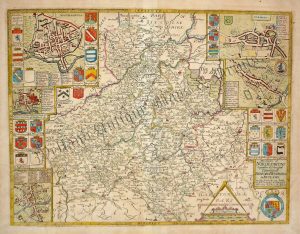
‘THE COUNTYE OF MONMOUTH wih [sic] the Sittuation of the Shire-towne Described’ by John Speed c.1610-1676
£
595.00
Add to basket
Add to Wishlist
Add to Wishlist
‘THE COUNTYE PALATINE OF CHESTER With that most ancient CITIE described.’ by John Speed c.1616
£
895.00
Add to basket
Add to Wishlist
Add to Wishlist
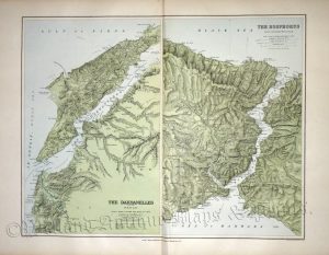
‘THE DARDANELLES AND THE TROAD’ / ‘THE BOSPHORUS AND CONSTANTINOPLE’ by E. Stanford c.1894
£
85.00
Add to basket
Add to Wishlist
Add to Wishlist
Out of stock
‘THE EAST INDIES’ [India & Indo-China] by Sr. Robert De Vaugondy c.1760
£
95.00
Read more
Add to Wishlist
Add to Wishlist
Out of stock
‘THE EAST RIDING of YORKSHIRE by Robert Morden’ c.1695
£
185.00
Read more
Add to Wishlist
Add to Wishlist
‘The East Riding of YORKSHIRE with Ainsty Liberty By JOHN CARY Engraver.’ c.1787
£
60.00
Add to basket
Add to Wishlist
Add to Wishlist
‘The East Riding of YORKSHIRE with Ainsty Liberty By JOHN CARY Engraver.’ c.1818
£
60.00
Add to basket
Add to Wishlist
Add to Wishlist
‘The EAST RIDING of YORKSHIRE, Drawn from the best Authorities’ by Thomas Kitchin c.1764
£
65.00
Add to basket
Add to Wishlist
Add to Wishlist
‘The EAST RIDING of YORKSHIRE, Drawn from the best Authorities’ by Thomas Kitchin c.1764
£
75.00
Add to basket
Add to Wishlist
Add to Wishlist
Out of stock
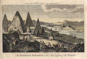
‘The EGYPTIAN PYRAMIDS with a View of part of the NILE &c.’ by Charles Middleton c.1778
£
45.00
Read more
Add to Wishlist
Add to Wishlist
‘THE ENVIRONS OF BELFAST’ by G. W. Bacon c.1884
£
32.00
Add to basket
Add to Wishlist
Add to Wishlist
‘THE ENVIRONS OF CORK’ by E. Weller F.R.G.S. / G. W. Bacon c.1884
£
32.00
Add to basket
Add to Wishlist
Add to Wishlist
‘THE ENVIRONS OF CORK’ by G. W. Bacon c.1895
£
20.00
Add to basket
Add to Wishlist
Add to Wishlist
‘THE ENVIRONS OF DUBLIN’ by G. W. Bacon c.1898
£
36.00
Add to basket
Add to Wishlist
Add to Wishlist
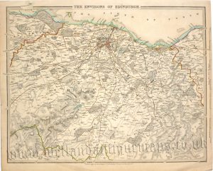
‘THE ENVIRONS OF EDINBURGH.’ by B. R. Davies (S. D. U. K.) c.1838
£
65.00
Add to basket
Add to Wishlist
Add to Wishlist
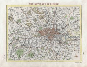
‘THE ENVIRONS OF LONDON’ by Thomas Moule / W. Hughes c.1840s
£
75.00
Add to basket
Add to Wishlist
Add to Wishlist
‘THE FALKLAND ISLANDS’ by E. Stanford c.1894
£
110.00
Add to basket
Add to Wishlist
Add to Wishlist
‘THE HEBRIDES & SKYE.’ by W. H. Lizars c.1893
£
28.00
Add to basket
Add to Wishlist
Add to Wishlist
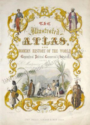
‘The Illustrated Atlas’ (title page) by H. Warren / J. Rogers / J. Tallis c.1851
£
100.00
Add to basket
Add to Wishlist
Add to Wishlist
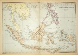
‘THE INDIAN ARCHIPELAGO.’ by E. Weller c.1884
£
55.00
Add to basket
Add to Wishlist
Add to Wishlist
Out of stock
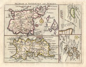
‘The Islands of GUERNSEY and JERSEY.’ / ‘ALDERNEY’ / ‘SCILLY ISLANDS’ by T. Read (J. Rocque) c.1769
£
70.00
Read more
Add to Wishlist
Add to Wishlist
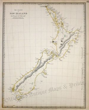
‘THE ISLANDS OF NEW ZEALAND’ by S. D. U. K / J. & C. Walker c.1838
£
200.00
Add to basket
Add to Wishlist
Add to Wishlist
‘THE ISLE OF MAN’ by E. Weller F.R.G.S. / G. W. Bacon c.1884
£
36.00
Add to basket
Add to Wishlist
Add to Wishlist
←
1
2
3
…
50
51
52
53
54
55
56
…
64
65
66
→
Home
About Us
Contact Us
Feedback
Recent Additions
Shop Online
Login
Register
Shopping Basket
Scroll to Top


!['THE EAST INDIES' [India & Indo-China] by Sr. Robert De Vaugondy c.1760](https://www.wellandantiquemaps.co.uk/wp-content/uploads/2023/01/East-Indies-Rodert-De-Vaugondy-02-copy-300x202.jpg)


!['THE COUNTYE OF MONMOUTH wih [sic] the Sittuation of the Shire-towne Described' by John Speed c.1610-1676](https://www.wellandantiquemaps.co.uk/wp-content/uploads/2023/01/Monmouth-Speed-copy-300x227.jpg)