Skip to content
Register
Login
Home
About Us
Contact Us
Feedback
Recent Additions
Shop Online
Login
Register
£
0.00
Search for:
Search
Our Range
Antique Maps
County Maps
Bedfordshire Maps
Berkshire Maps
British Islands
Buckinghamshire Maps
Cambridgeshire Maps
Cheshire Maps
Cornwall Maps
Cumberland Maps
Derbyshire Maps
Devon Maps
Dorset Maps
Durham Maps
Essex Maps
Gloucestershire Maps
Hampshire Maps
Herefordshire Maps
Hertfordshire Maps
Huntingdonshire Maps
Kent Maps
Lancashire Maps
Leicestershire Maps
Lincolnshire Maps
Middlesex Maps
Norfolk Maps
Northamptonshire Maps
Northumberland Maps
Nottinghamshire Maps
Oxfordshire Maps
Rutland Maps
Scottish Counties & Regions
Shropshire Maps
Somerset Maps
Staffordshire Maps
Suffolk Maps
Surrey Maps
Sussex Maps
Warwickshire Maps
Welsh Maps
Westmorland Maps
Wiltshire Maps
Worcestershire Maps
Yorkshire Maps
East Riding Maps
General Maps of Yorkshire
North Riding Maps
West Riding Maps
Foreign Maps
Great Britain & Ireland with Regional Maps
Renowned Map Makers
Road Maps
Title Pages / Frontispieces
Town Plans
Fairy Range
Other Prints
Topography
Home
/
Antique Maps
/
County Maps
/
Yorkshire Maps
/ General Maps of Yorkshire
General Maps of Yorkshire
Original Antique Maps of Yorkshire from the 17th to 19th Century.
‘A MAP of YORK SHIRE North from London’ by T. Badeslade / W. H. Toms c.1742
£
85.00
Add to basket
Add to Wishlist
Add to Wishlist
‘A New MAP of YORK SHIRE Drawn from the best Authorities’ by Thomas Kitchin c.1764
£
110.00
Add to basket
Add to Wishlist
Add to Wishlist
‘A NEW MAP of YORKSHIRE Drawn from the latest & best AUTHORITIES’ by Condor / Hogg c.1786
£
120.00
Add to basket
Add to Wishlist
Add to Wishlist
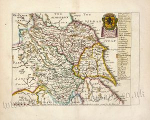
‘A Table of ye Divisions or parts wth ye Hundreds or wapontaks in YORK SHIRE’ by Richard Blome c.1673
£
275.00
Add to basket
Add to Wishlist
Add to Wishlist
Out of stock
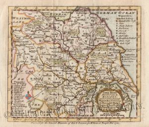
‘An ACCURATE MAP of YORKSHIRE Drawn from an Actual SURVEY, By T. Kitchin Geog:r’ c.1753
£
95.00
Read more
Add to Wishlist
Add to Wishlist
‘DUCATUS EBORACENSIS Anglice YORKSHIRE.’ by Joan Blaeu c.1645 (Latin Text Edition)
£
495.00
Add to basket
Add to Wishlist
Add to Wishlist
‘ENGLAND I’ by J. & C. Walker (S.D.U.K.) c.1831 / 1834
£
46.00
Add to basket
Add to Wishlist
Add to Wishlist
‘YORK SHIRE Divided into its RIDINGS: and Subdivided into Wapontakes …’ by Emanuel Bowen c.1762 (ex Gen Mag)
£
95.00
Add to basket
Add to Wishlist
Add to Wishlist
‘YORK SHIRE’ by John Speed c.1676 Edition
£
750.00
Add to basket
Add to Wishlist
Add to Wishlist
‘YORK’ (Yorkshire) by A. M. Perrot / Migneret c.1824-1835
£
110.00
Add to basket
Add to Wishlist
Add to Wishlist
‘YORKSHIRE By JOHN CARY Engraver’ c.1793 (New & Correct English Atlas)
£
65.00
Add to basket
Add to Wishlist
Add to Wishlist
‘YORKSHIRE By JOHN CARY Engraver’ c.1818 (New & Correct English Atlas)
£
65.00
Add to basket
Add to Wishlist
Add to Wishlist
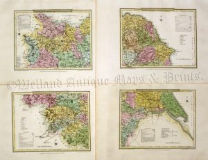
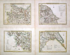
‘YORKSHIRE’ (on 4 sheets) by G. Cole & J. Roper c.1809 / 1810
£
80.00
Add to basket
Add to Wishlist
Add to Wishlist
‘YORKSHIRE’ (on 4 Sheets) by Joshua Archer c.1855
£
85.00
Add to basket
Add to Wishlist
Add to Wishlist
‘YORKSHIRE’ (on four sheets) by G. Cole & J. Roper c.1808 / 1810
£
80.00
Add to basket
Add to Wishlist
Add to Wishlist
‘YORKSHIRE’ (with extra page of text) by Seller / Grose c.1787
£
65.00
Add to basket
Add to Wishlist
Add to Wishlist
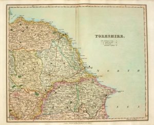
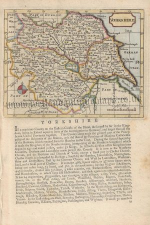
‘YORKSHIRE’ by ‘Reuben Ramble’ (Rev. Samuel Clark) c.[1844?] 1845
£
125.00
Add to basket
Add to Wishlist
Add to Wishlist
‘YORKSHIRE’ by Creighton / Walker / Lewis c.1844
£
55.00
Add to basket
Add to Wishlist
Add to Wishlist
‘YORKSHIRE.’ (on 4 Sheets) by H. Teesdale (R. Rowe) c.1832
£
120.00
Add to basket
Add to Wishlist
Add to Wishlist
‘YORKSHIRE.’ by James Pigot & Co. c.1830
£
140.00
Add to basket
Add to Wishlist
Add to Wishlist
Home
About Us
Contact Us
Feedback
Recent Additions
Shop Online
Login
Register
Shopping Basket
Scroll to Top


!['YORKSHIRE' by 'Reuben Ramble' (Rev. Samuel Clark) c.[1844?] 1845](https://www.wellandantiquemaps.co.uk/wp-content/uploads/2024/04/Yorkshire-Ramble-03-001-copy-300x371.jpg)